The death toll from the magnitude 7.8 earthquake tremor and its aftershocks that hit southeastern Turkey along its border with Syria continues to rise. As I write these lines, the death toll has reached 51,134. The first quake occurred at 4:17 AM (01:17 GMT) on Monday, February 6, 2023 and was centered in the Pazarchik district of Karamanmaras province. Less than 12 hours later, a second quake of magnitude 7.6 hit the same area. After the earthquake, more than 100 aftershocks were recorded.
On January 8, 2023, a magnitude 7.0 earthquake struck the South Pacific island nation named Republic of Vanuatu. On January 18, another moderate magnitude 7.0 earthquake hit Indonesia. A magnitude 6.1 earthquake struck the northern island of Hokkaido, Japan on Saturday, February 25, 2023, according to the U.S. Geological Survey. In the first two months of 2023, five large earthquakes ranging in magnitude from 7.0 to 7.9 were recorded in both countries (Syria and Turkey).
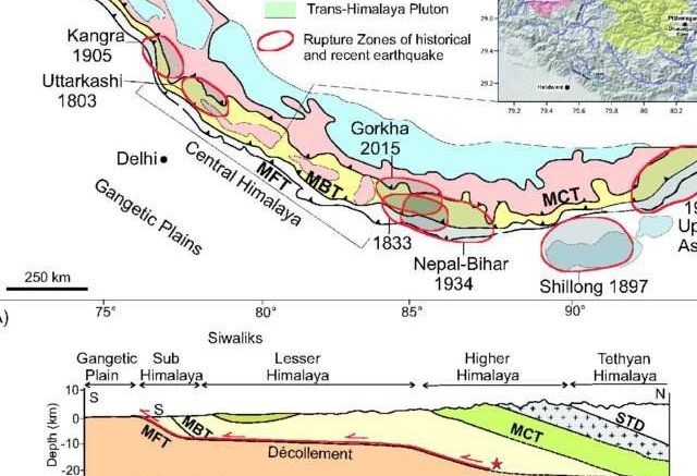
At the same time, many small tremors have been reported in the Himalayan belt, and it is predicted that sooner or later, larger earthquakes will occur in the Himalayan region. For this reason, seismologists suggest precautionary preparations to minimize loss of lives and damage to properties. It can be reported that, at least four large earthquakes have been reported in the Himalayan region in the last 150 years. Some were reported in Shillong in 1897, in Kangra in 1905, in Bihar-Nepal in 1934 and Assam in 1950.
The highest and youngest mountain range in the world, the Himalayas straddle India, Nepal, Bhutan, China (Tibet) and Pakistan and have witnessed many major natural disasters, especially earthquakes that have devastated the region. Man-made infrastructure has claimed thousands of lives, and seismologists around the world are confident that they likely witnessed an earthquake above 8 on the moment magnitude scale in the Himalayan belt possibly in the three regions (one between central Himachal Pradesh and northern Bihar, another between the Shillong Plateau and Mishmi Hills in Arunachal Pradesh and another in Kashmir).
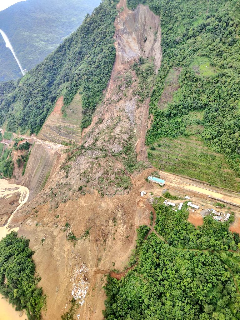
It has been noted that, the uncontrolled and unsustainable urbanization of the Darjeeling Hills and its surroundings falls within focal seismic zone IV (Severe Seismic Intensity Zone) could wreak havoc in the near future.
According to the Census 2011, the district has a total area of 3,149 sq km., 153.49 sq km is urban and 2995.51 sq km is rural. Out of total population of Darjeeling, 2,049,974 in the district, 727,963 are in urban area and 1,118,860 are in rural area.
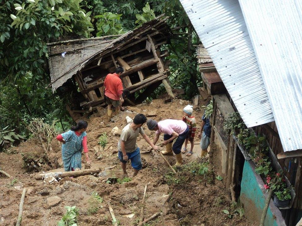
Rapid population influx towards the town for better livelihood, quality education, daily wages labour opportunities and unsustainable tourism practices creates much anthropogenic pressure on fragile hill slopes of Darjeeling. Annual water crisis, congested traffic and urban planning and unchecked migration in the local towns of the Darjeeling are the major factors for rapid urbanization in our towns.
Our towns are already over-burdening due to many aforementioned major factors. In the urban areas (Municipal bodies), it has been stated that, under Rule 162 of West Bengal Municipality Building Rule 2007, hill urban civic bodies can sanction building plans up to a height of 11.5 meters (roughly four-storey building). Civic bodies need to get prior approval of the state government for construction up to 13.5 meters. Unfortunately, in the Darjeeling hills urban area, there are many illegal multi-storey buildings denotes a trap for future calamity.
Lack of understanding on structural risk of buildings and town planning is also one of the reasons for unplanned urbanization in the hills. Additionally, majority of buildings are falls under earthquake-induced landslide area in the hills which might trigger more fatality after any major tremors.
Unmanaged and unsustainable mushrooming tourism development also creates major mismanagement in the hills. The ongoing unchecked and unsustainable development in the hills creates lesser opportunities for local civic administration to keep balance between supply and demand systems for local inhabitants. This result, a chaotic situation in urban planning as expected.
What can we do to be prepared for any major earthquakes?
- Sustainable urban development plans needs to be adopted by the local administration without any compromises with safety norms and environmental hazards.
- Sustainable tourism development model needs to be implemented while due to unmanaged tourism development, we are losing our attraction from rest part of the world. We all aware that, tourism is a major financial backbone to run livelihood of local inhabitants in the hills. Therefore, long-term and balanced tourism development plans need to ensure urgently in the hills.
- Widespread awareness may require to be prepared for any disaster. This might help to save more lives.
- The cooperation and contribution of local residents are urgently needed to maintain a healthy and safe place from natural disasters. Local residents must play a pivotal and responsible role in keeping our places safe and harmless. It’s not just about blaming the concerned authorities. As citizens, we must do our part responsibly.
Conclusively, let us recall few lines of Nepali Poem written by कवि शिरोमणि लेखनाथ पौड्याल which gives us more enlighten on our greedy nature towards ‘live and let live’ way of living as follows:
“मैं खाऊ, मैं लाऊँ, सुख सयल वा मौज त्यो गरूँ,
म बाँचू, मै नाचूँ, अरू सबै मरून दुर्बलहरू,
भनी दाह्रा घस्ने अबुझ गठदेखि,
चिता खिस्का छोडी हाँस्यो मरी-मरी….।।“
[Writes – Noel Giri, Sukhia Pokhari]
Leave a comment