
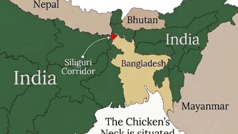
Siliguri Corridor, flanked by Nepal, Bhutan and Bangladesh has emerged as the most important national security concern for India. Dr. Vimal Khawas calls for the establishment of Siliguri Corridor Integrated Management Authority (SCIMA) for its holistic management.
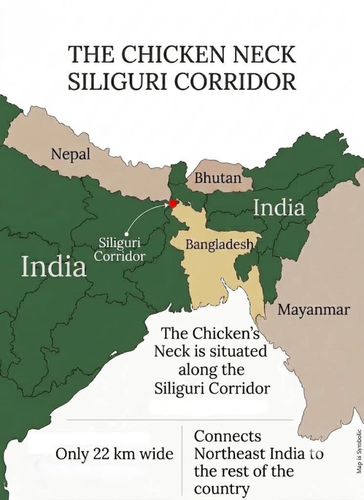
The Siliguri Corridor, a small piece of land in northern West Bengal, measuring roughly 60 kilometres in length and 20 kilometres in width and covering an approximate area of 1,200 square kilometres remains one of India’s most consequential geographical features. Popularly known as the “Chicken’s Neck,” this narrow passage serves as the sole continuous overland link between the eight northeastern states and the rest of the country. Its strategic location, historical formation, geopolitical sensitivities, and growing economic and environmental weight together make it far more than a transit zone. It is a national artery whose integrity underpins territorial cohesion, regional influence, and sustainable development in eastern India.
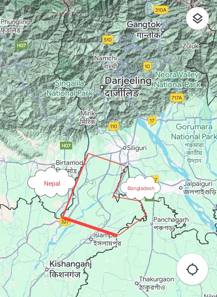
The Corridor’s present shape emerged from successive historical processes. The Partition of 1947 left only a thin land bridge after the creation of East Pakistan. Internal boundary adjustments under the Transfer of Territories Act of 1956 actually refined its contours by transferring territory from Bihar to West Bengal. The independence of Bangladesh in 1971 closed many alternative routes and elevated the Corridor to the status of an indispensable lifeline. Earlier colonial conflicts and treaties, including the Anglo-Gorkha War, the Duar War, and the treaties of Sugauli and Punakha, had already highlighted the area’s topographic importance. In the decades after Independence, the 1950 Treaty of Peace and Friendship with Nepal reinforced free movement across the northern borders, while restricted transit through Bangladesh solidified the Corridor’s exclusive role in connecting the Northeast to the Indian mainland.
The region’s hydrology has itself been profoundly shaped by natural upheavals. A major avulsion of the Teesta River in 1787, triggered by catastrophic monsoon flooding, permanently altered its course. Previously flowing southward through channels such as the Punarbhaba, Atrai and Karatoya toward the Ganges, the river shifted southeast to join the Brahmaputra and fundamentally reshaped the alluvial landscape of the Corridor and its surrounding plains. This historical instability continues to define the area’s vulnerability. The devastating floods of October 1968 caused by intense cloudbursts and prolonged rainfall over the Darjeeling-Sikkim Himalaya triggered hundreds of landslides, washed away critical bridges including the Anderson Bridge on the Teesta severed road and rail links between Siliguri and the hills and claimed hundreds of lives while inundating large parts of the North Bengal plains. More recently, the glacial lake outburst flood (GLOF) of 3-4 October 2023 from South Lhonak Lake in Sikkim sent a massive surge of water and sediment cascading hundreds of kilometres down the Teesta destroyed the Teesta-III hydropower dam, damaged infrastructure across Sikkim and downstream districts of West Bengal near the Corridor, and extended impacts into Bangladesh. These events clearly highlight that the Corridor’s narrow geography is not only a product of political cartography but also of a dynamic and often violent fluvial and climatic regime.
Wedged between Nepal and Bhutan to the north and Bangladesh to the south, and lying in proximity to China’s Chumbi Valley, the Corridor occupies a uniquely sensitive position. The Mahananda and Teesta rivers add hydrological complexity, while the narrow width means that any sustained disruption, including military, natural, or demographic, could effectively isolate the Northeast. This geography has long rendered the Corridor both indispensable for the movement of people, goods, and armed forces and inherently vulnerable to external pressure or internal instability. Geopolitically, the passage sits at the confluence of multiple interests. It is the primary land gateway through which India advances connectivity and influence toward Southeast Asia. At the same time, its open borders with three neighbouring countries create persistent challenges of illegal immigration, trafficking, and the movement of hostile elements. Often reported demographic shifts in the surrounding districts and the Corridor’s nearness to Chinese territory further intensify strategic calculations, making secure control over this strip inseparable from the defence of the Northeast and the stability of India’s eastern frontier.
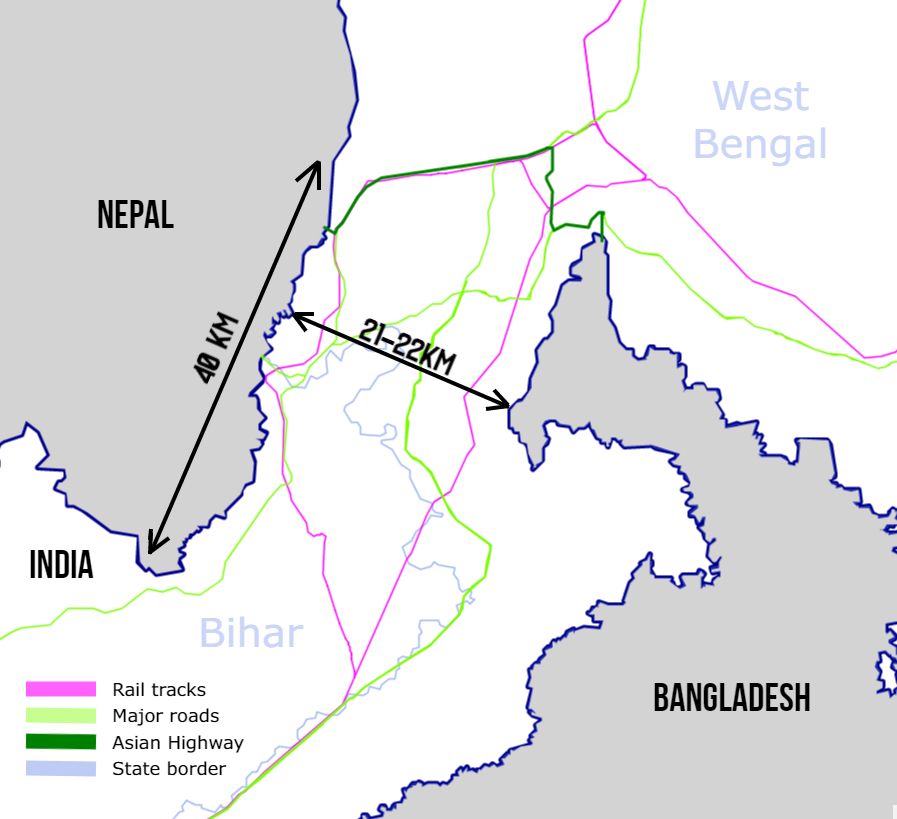

Besides its geopolitical and strategic significance, the Corridor also holds tremendous geo-economic and geo-environmental importance that demands equal attention. It functions as a key route for the trade and transportation of goods between mainland India and the northeastern states, as well as with neighbouring countries such as Nepal, Bhutan, and Bangladesh. Improved road, rail, and logistics networks through Siliguri have transformed the region into a commercial hub that sustains economic activity across the Northeast. The Corridor likewise plays a crucial role in promoting tourism to the northeastern states, destinations celebrated for their rich biodiversity, scenic beauty, and cultural heritage. By enabling easier access for visitors, it supports local livelihoods and strengthens the broader case for regional integration and investment.
This unique geographical piece of land is simultaneously an ecological hotspot harbouring diverse flora and fauna. It serves as a crucial elephant corridor, facilitating the seasonal movement of these animals between India, Nepal, and Bhutan. Dense forests and extensive tea gardens provide habitat for numerous species, contributing substantially to the region’s biodiversity. Yet increasing human activity including urban expansion, infrastructure projects, and intensified agriculture, poses a significant threat to this ecological balance. The Corridor’s vulnerability to climate-induced natural disasters, illustrated so starkly by the 1787 Teesta avulsion, the 1968 floods, and the 2023 GLOF, further exacerbates the environmental challenges facing the region. Any long-term strategy for the Corridor must therefore reconcile security and connectivity needs with the preservation of its fragile ecosystems and the management of recurrent fluvial hazards.
Against this layered backdrop of history, strategy, economy, and ecology, Union Home Minister Amit Shah’s statements during his recent visit to Siliguri have brought focused attention to the practical requirements of safeguarding the Corridor. He described the Siliguri Corridor as one of the most sensitive and critical zones in the country, connecting eight northeastern states to the rest of India and therefore is vital for national security. Shah directed security and administrative agencies to take strict action to stop illegal immigration. He advised authorities to keep the land free of illegal encroachments. He further instructed agencies to expand their local footprint by establishing more official institutions in the region. On the operational side, he highlighted plans for a triangular security grid built around three new military garrisons at Dhubri in Assam, Kishanganj in Bihar, and Chopra in West Bengal. These bases are intended to strengthen surveillance, presence, and response capacity around the Chicken’s Neck. Complementing this structure, Shah pushed for an integrated defence model that brings together local community intelligence, the civil administration, state police, and central military forces. He also called on local leadership to strengthen civil defence units, home guards, NCC cadets, and Sainik schools in North Bengal and recognised that durable security rests on both professional forces and an engaged civilian foundation.
While these directives correctly identify the urgency of hardening physical control and improving inter-agency coordination, they largely remain incomplete if treated solely as a security-centric package. An implementable policy complement would be the formal establishment of a Siliguri Corridor Integrated Management Authority (SCIMA), a statutory body under the Ministry of Home Affairs with representation from the Ministries of Defence, Environment, Forest and Climate Change, and Development of North Eastern Region, as well as the governments of West Bengal, Assam, and Bihar. Critically, the very idea of the Siliguri Corridor remains rather vague in official discourse. Its precise spatial limits have never been formally delineated beyond approximate descriptions of length and width. SCIMA’s first mandate must therefore be a scientifically grounded cadastral and geospatial exercise to define the Corridor’s exact boundaries, incorporating hydrological, ecological, and infrastructural criteria rather than relying on informal cartographic conventions. Parallel to this, the Authority should commission a rigorous, transparent demographic study of the delineated zone. Recent comments by Assam Chief Minister Himanta Biswa Sarma which have highlighted substantial demographic shifts and suggested that significant portions of the Corridor and its adjoining areas are now inhabited by populations of Bangladeshi origin, emphasis the necessity of evidence-based examination rather than rhetorical assertion.
Such a study, conducted with due process and independent oversight, would provide the empirical foundation for targeted enforcement against illegal immigration while distinguishing long-settled Indian citizens from recent irregular entrants. SCIMA would further operationalise the triangular grid and multi-agency model by embedding continuous ecological monitoring and disaster-risk assessment linked to land-use regulation. In addition, SCIMA would create a structured community-intelligence interface that institutionalises civil defence, home guards, NCC, and local institutions as permanent partners. Without this institutional layer, the risk remains that kinetic measures will outpace the social and environmental foundations upon which long-term control ultimately depends.





Be the first to comment on "Siliguri Corridor: Between Strategic Necessity and Ecological Precarity"